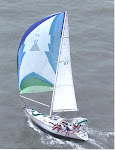
White Pepper finally reached San Salvador on Saturday, April 9, 2011 almost 520 years after Christopher Columbus first stopped here. White Pepper came from Rum Cay in a 41 foot sloop. We had to beat against a NE breeze. Columbus' ships were only slightly larger but came from the Azores running most of the way. Several alternative first landing sites have been proposed and the controversy will likely never be settled. However, the case for San Salvador is compelling. There are actually several small artifacts that link 13th century sailors with Arawak Indians. These are in a museum on Sal Salvador. We wanted to see these, but the museum is closed and under reconstruction. Columbus described the new island as bean shaped and filled with lakes both very characteristic of San Salvador. My favorite bit of evidence is Grahams Harbor, a well protected road stead on the northern shore. Columbus reported “a lake large enough to hold all of the ships of Christendom.” Grahams Harbor could easily fit that description. Columbus first anchored for the night on the rocky eastern shore. This spot is marked by the Chicago Herald memorial placed there at the time of the Chicago World's fair. A picture of the beach and memorial are below.
The next morning, Oct 19, 1492, Columbus moved around to the sheltered bight, on the western shore of this bean shaped island. White Pepper followed the same strategy anchoring off Cockburn Town in 9 feet of the clearest water and cleanest sand I have ever seen. Columbus anchored about 3 miles further south in Long Bay. An underwater memorial marks the likely spot. Pic below.
The colors of San Salvador are the most intense I have witnessed, especially the blues. I think that the reason is that the shore drops off so quickly. Only 200 yards off shore the water depths drop to thousands of feet. It would be possible to deep sea fish for marlin or sail fish with our dingy, Habenero. The water and air are as clear the Atlantic Ocean which exactly where we are. San Salvador is the very top of large mountain that comes straight out of the abysmal plain of the southwestern Atlantic Ocean. This does not do justice to the drop off.
On Sunday the island was closed as is typical of the Bahamas. We did hike to the Riding Rock Marina Inn and had a wonderful lunch of cracked conch overlooking the reefs of Riding Rock Point. Monday we did chores. We dingied into the Riding Rock Marina where I got some diesel and Jan went on the get money at the bank. Then we shopped in Cockburn for supplies. I arranged for a tour of the island with Nat Walker. Nat is a bus driver and sometimes tour guide. He is an engaging, well educated and widely traveled Bahamian. He has come back to San Salvador to raise a family and help with the family bus business. On Tuesday as Nat drove us around the island we saw the vast calm expanse of Grahams Harbor and the marine science institute run by an American college. We stopped at the light house atop Dixon's Hill (elev. 79 feet) and climbed to the top. The light house is actually working and still runs on 1890's technology. Two families supply the lighthouse keepers who live on site. Here are pictures of the lighthouse some of the 19th century machinery still in use.
The view from the top of the lighthouse gave a spectacular panorama of all of the northern coast but more interestingly of the vast systems of salty lakes that comprise much of the interior of San Salvador. This view is towards the north. Graham's Harbor is in the distance.
We drove along the deserted eastern shore. Only several families live on this stretch which once housed thousands in the plantation days. There is no electricity on this side of the island and any settlers are truly off the grid. On the southern shore we stopped at Watling's Castle which is an easily accessible ruin of a once successful plantation. San Salvador was once called Watling's Island.
The last stop on the tour was a visit to the Columbus memorials on Long Bay. There are several memorials grouped together. One was placed on the site by the Spanish government in 1992 to commemorate the visit by the Columbus fleet replicas. I may be mistaken by I believe that these are the very ships that were purchased by the city of Corpus Christi and now reside on the bayfront. Another memorial was placed by the Mexican government to commemorate the passage of the Olympic flame on its way from Greece to Mexico for the 1968 Olympics. The small white cross is the "official" Colombus Memorial. Note the catameran, Guiding Light, in the background. Her owner, Shane, took these pictures and graciously let me publish them.
On our last day we took Habenero to several snorkel sites. Moorings are maintained by Club Med so we did not have to anchor. After snorkeling we carried on the Long Bay and again visited the Columbus memorials for a picnic lunch. As we came ashore I claimed all of the New World in the name of Queen Jan. Seriously, Long Bay is a lovely beach with long stretches of soft white sand and would be a tourist destination without the history. There is good snorkeling just off the beach in warm shallow water. We had the entire place to ourselves. It did give me a tingle to imagine my footsteps crossing those of Columbus.
On Thursday we sailed west back to Cat Island sad in the knowledge that San Salvador was the high water mark of our cruise. Now we were head back to Florida although slowly.


No comments:
Post a Comment