


Hatchet Bay in northern Eleuthra Island claims to be the safest harbor in the Bahamas. It would be hard to dispute that based on geography. Despite the favorable topography hurricane Floyd did a number on the area as well as the rest of the Bahamas. White Pepper easily made the 15 miles from Governor's Harbor to Hatchet Bay. We entered the harbor through a cleft in the cliffs that could not have been 100 feet wide. There was plenty of water. Entering the harbor it opens into a deep and fairly wide anchorage which is protected 360 degrees by high cliffs. There are even several free mooring balls. Despite all of this amazing protection, we could see little marine activity. The marina has dried up. There is a large concrete government dock, but no fuel or water. There were few boats around. We did link up with Izzy R, our new friends from Governor's Harbor. We all had a nice dinner at the only establishment about which was the Front Porch.
The next day Jan and I walked the short distance to Alice Town. Alice Town was a pleasant surprise. It was large by Eleuthra standards. Everyone was very friendly. There was a large park and playground. Most of the homes were well kept. Some had extravagant gardens of gardenias, bougainvilleas, and hibiscus. We wondered how the locals maintained these homes since there was no industry about. Certainly there was no marine or fishing industry. The only employment opportunities inside the city limits seemed to be churches, bars, and numerous small convenience stores. Finally we decided that the locals must be employed in the hospitality services else where on Eleuthra.
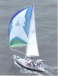
A reason to stop in Hatchet Bay is to pass through Current Cut on the way the Spanish Wells and the other other heavily populated areas of northwestern Eleuthra. Current Cut is just what it sounds like—a very narrow cut with fierce current. White Pepper's sorry motor can not handle currents that can exceed 4 knots so we resolved to time the slack water. Consulting the tide tables I saw that the only slack water available within 3 hours of sunrise or sunset was the low tide at 13:29. We set out to cover the 15 miles from Hatchet Bay to Current Cut at 9:30 with a gentle wind from the East blowing us due West. However, the wind continued to build relentlessly. Despite reducing sail several times the old girl kept going faster and faster. Eventually we arrive at the way point about 45 minutes before low tide. There was nothing else to do except go for it. With a bit of sail assist, the Yanmar motor going full out, and my eyes glued to the Garmin chart plotter, we turned the last corner safely and blasted through the cut at 10 knots. The wind was whistling, the scenery was spectacular, the green water was doing its current/wind lap dance and my heart was beating like a drum. Jan was as cool as a cucumber and enjoying the scene immensely. Within seconds we were spit out unto the banks and headed for Royal Island. I felt an immense sense of accomplishment and proud to have checked that one off my bucket list. But if I am ever crazy enough to try Current Cut again, I am going to arrive 20 or 30 minutes after high or low water. Or I will just head for Fleeming Cut which is only several miles south and does not have any current issues at all.
The pictures are of White Pepper proceeding from Hachet Bay to Current Cut under reefed genoa only. Izzy-R took these pics. The waterscape is a file photo of Hachet Bay.
The pictures are of White Pepper proceeding from Hachet Bay to Current Cut under reefed genoa only. Izzy-R took these pics. The waterscape is a file photo of Hachet Bay.
No comments:
Post a Comment