Monday, February 10, 2014

Little Harbor, Berry Islands--The Cabbage Island Anchorage

From Great Harbor to Little Harbor in the Berry Islands is an easy 22 n.mi. day sail. The entrance is deep and wide open. There is a selection of anchorages. The recommended anchorage is to the south behind Frozen Cay. Frozen Cay used to be called High Cay only a few years ago (including on my old Map Tech charts). This day White Pepper chose the anchorage behind Cabbage Cay because we wanted to be closer to the settlement at Little Harbor (more about that later) and because the weather was quite settled.

This latter fact was quite important as the anchor never bit. The ground looked like sand but acted like rock. None of the three boats in our anchorage ever got a set. However, the wind was so light that we lay to the chain for two days. The anchorage was a bit rolly. It was nothing too uncomfortable. I could see that in any kind of weather things would get really out of hand. The take away lession here is that I can not recommend the Cabbage Cay anchorage.

Little Harbor proper has a recommendation as a hurricane hole if one can tuck in close to the settlement. However, the depth is so shallow that one would have to wait for the storm surge to get in. If White Pepper ever comes this way again, she will opt for the remote Frozen Cay anchorage.

Eventually we did get into the “settlement” and to the famous Flo's Conch Restaurant. We were fortunate to meet Flo's daughter. She told us that her mother had passed three years ago. Her brother and his wife ran the restaurant. These were only two people left on the cay that had supported several families and 50 people in years past. She and her sister worked as personal assistants (nurses' aides) in the USA. We walked around the place. It was a compound of about an acre with cistern, generator, chickens, and geese. There was no road and no path to anywhere. There were enormous piles of conch shells along the shore that represented maybe 50 plus years of harvest. I found it remarkably isolated even by the standards of the Bahamian out islands. Soon enough no one will live here.


On a more cheerful note the conch lunch and Kalik beer were delightful, if overpriced. But one has to consider the effort required to hold back the bush in the price of the food.

 Carved Conch Shell

 Deserted Beach

Flo's Back Yard
Flo's Famous Conch Restaurant


Little Harbor 

Don't Try This at Home, Folks--Great Harbor, Berry Islands

Sunrise Great Harbor, Buddy Boat Gizmo in Foreground

The major problem with entering the Bahamas at Port Lucaya on Grand Bahama Island is that you need a weather window to leave. It is 55 nautical miles to the nearest Berry Island, and that is due SE into the teeth of the prevailing winds. White Pepper had a good window to leave in front of a stationary cold front. Winds were predicted to be light from the south or southwest and seas calm. We cleared the jetties at dawn at 7 am. Indeed the morning started out exactly as predicted. We made good speed with gentle breezes abeam or just forward of the beam. Trimming the sails precisely for a close reach on starboard and motoring we were making good progress. In the afternoon the winds stayed light but gradually veered to the ESE which made a head wind. The motor got so hot I had to back off to avoid starting a fire on the boat. Eventually, the wind came around enough to reset the genoa on a port board. However, by this time our window for a daylight arrival had expired. We arrived at the Great Harbor waypoint at 7:30 pm about an hour after dark.

Conventional wisdom, endlessly repeated, is to never enter a strange port at night. Countering this ancient and sound advice was a powerful desire not to spend the night at sea. Also in our favor was a bright moonlight, calm seas, and almost no wind or current as it was slack water. The opening is about 300 yards wide which is quite large by local standards. Great Harbor is an old and historic harbor for ships transiting the Gulf Stream and Bahamas. It is tucked up between Great Stirrup Cay and the northern tip of Great Harbor Cay. It gets poor reviews from the cruising guides, but who cares about surge and current when the alternative is the deep blue sea of the Northwest Providence Channel at night.

The Garmin chart plotter was spot on guiding White Pepper through the opening and to a safe anchorage in 10 feet of water. The land was dimly visible in the moonlight. There were, of course, no aids to navigation. Later, after celebratory rum, I thought that isn't this the way we enter all anchorages nowadays—with eyes glued to the chart plotter? Aren't all landings just instrument rated landing even in visual rated conditions?

Just because we got away with it I do not recommend entering Great Harbor at night. I would , however, take the same window again if it comes up. But next time I will leave Port Lucaya at 4 am.

Finally, what's a good sailblog worth without a cute kitty picture?

Aphrodite

Sunday, January 26, 2014

Car Trip to Eastern Grand Bahama Island

Deep Water Cay from MacCleans, Grand Bahama Island

Our Bahamian friends, Paula and Don, took us for a lovely Sunday afternoon tour of the eastern side of their island, Grand Bahama Island.  To be truthful, the interior of the island is desolate, undeveloped scrub and scrawny second growth pine.  The island was heavily logged in the mid 20th century.  

First stop was at the Lucayan National Park where we got a hint of what the island may have looked like originally. This stuff was impenetrable without trails. The Bahamians use the word coppice to mean ecosystem.  (The English use a different meaning.) The rocky coppice is occasionally flooded at high tide.  

Discussion of the Rocky Coppice

Example of Rocky Coppice

We crossed a wonderful salt water creek with hundreds of fish visible in the shallow, clear water.

Salt water creek in Lucayan National Park

My shadow (lower left) taking a picture of large mangrove snapper

Several hundred yards further on brought us to the lovely Gold Rock Beach on the southern shore of the island. The very deep water Northwest Providence Channel in the background.

Gold Rock Beach looking East

Gold Rock Beach

Then we motored on to the town of Pigeon Settlement and past the homemade light house of the Light House Church of the Later Day Saints. It later showed up on the label of a local beer much to the dismay of the church.

                                 Light House in distance, may need to click on pic to see.

The eastern most settlement on Grand Bahama Island is MacCleans (sic).  We had driven about an hour or 50 miles from Freeport. MacCleans has a daily ferry to Abaco Island and several very neatly kept houses, churches, school and a clinic.  We found a local restaurant, E. J.'s Bayside Cafe,  and were delighted with the cracked conch and the service.  Here is a pic of us outside the restaurant. In the unlikely event that you are passing this way (and it is far off the beaten path), I can highly recommend the food.
Karl, Jan, Paula and Don at E. J. 's


Friday, January 17, 2014

Port Lucaya in Winter

Why has White Pepper taken a slip for a month at Port Lucaya Marina, Grand Bahama Island, while our Canadian friends bravely battle their way South down island this January?  "Because it's the Winter, Mon."

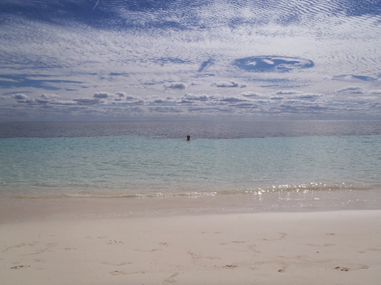
Yes, January is winter in the Bahamas and one cold front after the other whistles overhead.  This week alone we have had cold fronts on Thursday, Saturday, and Sunday.  Here is a pic of Jan swimming on Friday with a very wintery sky overhead.  Note the cirrus and scabrous clouds.
Winter Sky, Warm Water

This week has brought days of sustained westerly and northwesterly winds that render the traditional Exuma anchorages uncomfortable or downright untenable.  And I feel sorry for the Abacos sailors where protection from the west is rare.

All is not lost, however,  we follow the cruise ships that frequent Port Lucaya.  Here is the massive Costa Luzencia in the background. There is always live entertainment in the Port Lucaya village whenever a cruise ship is in port or offshore.

We attended a fish fry with out Bahamian friends Paula, Don and daughter Megan.  Megan is a freshman in medical school in Trinidad. I will play golf with them later this week.
Megan, Paula and Don
Also, new friend and slip neighbor, Dennis, has been catching wahoo. He gives us a few pieces.
Dennis and wahoo

We walk, shop, and kayak.  Most of the boat chore are caught up by now. In February when the fronts slow down we will head South.

Saturday, January 11, 2014

Majority Rule Day

January 10th has always been important to the Bahamians.  On that day in 1967 they voted in the first free and fair election in Bahamian history.  Majority (black) rule soon ensued.  The day is even more dear to them than Independence Day on July 10th.  2014 was, however the first time the day was celebrated as a legal holiday, and White Pepper was pleased to participate.  First we met our friends from Grand Bahamas, Don and Paula von Hamm.  Don is a semi-retired professor of history at the local college in Freeport, and Paula works in real estate. Alert readers will remember Paula from my post in April 2011 "Easter at Rock Sound."
The von Hamm's with Jan

We all headed for downtown Freeport where speeches and marches were underway.  Here is the Fire Department Marching Band.

                                                           Fire Department Band

Don and Paula let us go early as today was our 10th anniversary (observed).  Actually our anniversary was January 2nd. We were pinned down in Lake Worth, FL waiting out a cold front and could not get off the boat.  We celebrated 10 wonderful years of adventure at Cappuccino's--a surprisingly good Italian restaurant in the Lucaya Village.
Tenth year anniversary

The menu was grilled scallops, blue cheese gnocchi, salad, grilled wahoo, and Tira Missou.  Here's to 10 or 20 more years.

Monday, January 6, 2014

Crossing of Anxiety


White Pepper's previous two eastbound crossings of the Gulf Stream were more a matter of guess work and hilarity. Please see previous posts for details. A good analogy would be crossing an Interstate highway at midnight blindfolded. You might make it across, but maybe not. More on this analogy later.

On this crossing I was determined to use all the available tools. I paid for a weather adviser—Chris Parker-- $80 for 2 months of of e-mail updates. I paid for Sailflow --$3/ month. Sailflow provides 8 grib models of weather as well as there own proprietary product. And of course there are literally hundreds of products available from NOAA via the internet. All of this resulted in immense uncertainty.

The great game of the Bahamas bound cruiser is to find a “window” when the weather provides gentle favorable breezes and the seas are mild. An ideal scenario would be 12 knots out of the SW with no waves. Impossible you say, but just such conditions occur before major cold fronts as the high pressure system clocks the wind from E to SE, S, SW and W prior to blasting the area with strong NW winds. There is only one iron clad rule for crossing the Gulf Stream-- no north winds. Any north winds of any strength ruffle up the Gulf Stream. Getting caught here can be catastrophic. A second rule may be to avoid strong winds and waves from any direction. Extending the previous analogy this is like crossing the Interstate highway but only when the a big truck is coming. The truck can speed up or slow down. You do not have to put the blindfold on until starting across the highway. Also the earlier truck is allowed to back up. and any slow moving trucks can send smaller trucks zipping ahead.

Late December 2013 and early January 2014 brought great difficulty in the weather. One cold front after another rumbled off the south eastern coast of America. In addition most of these backed up over the Bahamas to cause great confusion.

White Pepper arrived in Lake Worth/ Palm Beach, FL New Year's Eve from Vero Beach. We waited out a rip roaring cold front at anchor. It was moving so fast that crossing ahead of it did not seem advisable although several strong boats did go. “Bouncy” was the work we got back. The next front was due to cross late January 6 with a “window” maybe January 5 and early 6. This was the front associated with the immense polar air mass described in the papers as the largest, coldest invasion of polar air into the continental US in 20 years. Chris Parker said that there may not be another good opportunity until a week, maybe, after this one. However the front was so large that conditions in advance were uncertain. The GRIB files changed daily. What seemed an ideal window early looked very rough later. Ominous reports of 3-4 foot NE swells in addition to 5-6 foots seas were forecast.

We moved to the launch area south of Peanut Island and behind the fabulous homes of Palm Beach. When the day of decision came on Sunday January 5, I must have consulted the computer 20 times. Every hour seemed like a day. A hugh complication was that a “convergence” trough had formed just off the beach of southeastern Florida. One squall after another rolled over us all day. My fear was that the trough would regenerate when it drifted over the warm waters of the Gulf Stream. I did not want to go. However, the alternative was another week at anchor with freezing temperatures. Jan pointed out that we were running out of supplies including propane.

Every hour was an agony of worry. By 3:30 pm I had decided not to go. This was in the middle of a thunderous squall. By 4 pm it was calm and a beautiful sun set was setting up. I said “let's go” and started to raise the anchor. We cleared the jetties by 5:15 pm in perfect conditions.


The crossing was exhilarating. About 9 pm the very early S wind clocking to SW picked up. This was the very earliest part of the new system. White Pepper romped across the Gulf Stream. With reefed main and reefed Genoa on the power reach she clocked 5 knots into the teeth of the stream. She acted like the thoroughbred racer she once was, despite another 6 inches of waterline. We no longer have a paddle wheel, but I estimate speed through the water at 6.5 plus. Wind speeds were moderate at 14 to 16. Sea state was mild. We raised Freeport before dawn and cleared into Port Lucaya about 11 am. By 9 pm the gale was whistling over White Pepper --safely at dock.

Wednesday, January 1, 2014

26 Days at Vero Beach

 White Pepper and Utopia share a mooring ball
Sharon and Davido

We sadly cast off the lines on Monday December 30, 2013 after 26 days at Vero Beach, FL. We were sad to leave our new friends and mooringball neighbors, Davido and Sharon, of s/v Utopia. We were sad that our buddies, Ken and Connie, of s/v Oz had left several days earlier. We were sad to leave the exquisitely beautiful weather that we had enjoyed for our stay. With weather like we had had, why go to the Bahamas​? But nothing lasts forever and we had to press on South.

White Pepper had accomplished much at Vero Beach. We had ordered and installed a new radio with AIS capability and a Globstar sat phone. I added two additional bow cleats. The long term project of replacing all of the interior lights with LEDs was completed. Mail drops were completed, prescriptions filled and final supplies for the Bahamas topped up. Jan's favorite rod was repaired at the local fishing supply store. Christmas was celebrated with a gourmet dinner on board Oz as both crews chose to avoid the pot luck this year.

Vero Beach has been aptly termed “Velcro Beach” with good reason. We met several couples who had traded their boats here for homes. They call themselves CLODs and meet regularly for breakfast. One CLOD, Harriet, graciously drove us to Lowes and Walmart.


Monday brought a long run down the ICW past Jensen Beach and St. Lucie's Inlet. We put the anchor down at Hobe Sound as the sun was setting. Hobe Sound is the narrow sound behind Jupiter Island. This place was once the richest Zip Code in America. Tuesday we only traveled 20 miles but they were aggravating because of five bascule bridges and the current at Jupiter Inlet. Finally we entered Lake Worth in North Palm Beach to celebrate New Years Eve.