Friday, April 7, 2017

Conception Island


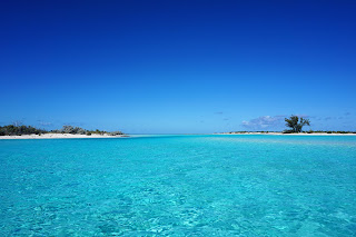
White Pepper has blogged expansively about Conception Island, Bahamas during a previous visit. This year we again visited; this time with guest Barb Mathis aboard. With White Pepper's powerful new motor she was able to power directly into a gentle Northeasterly breeze for 7 hours arriving in the mid afternoon of the first of 4 lovely days. We were fortunate enough to catch a small Mahi-mahi two miles west of Cape Santa Maria. It provided two great dinners.

Conception has not changed. It remains one of the most pristine and beautiful of all of the Bahamas islands. It is uninhabited and protected by the National Trust as a Land and Sea Park. One change that I did notice was how many yachts were there. There were 8 normal sized yachts anchored along the shore of the favored West Bay Anchorage and 4 mega yachts anchored in deeper water. Conception has become popular!

170 foot ketch Adele at sunset

We walked the lovely beaches. Barb is a birdwatcher of note from Rockport, TX and was pleased to see the birds of Conception. Her constant worry was how few birds there were. All through out the central and southern Bahamas the bird population is severely limited by lack of fresh water.

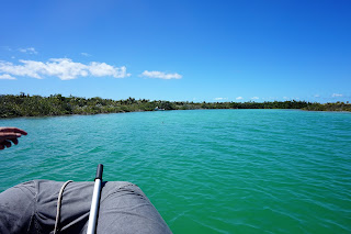
Day two was devoted a dingy trip up the creek to see the Green turtles. The creek does not have a name that I am aware of. It is the mating and nesting site of numerous Green turtles. One deep and very green hole about a mile up the creek is said to be the origin of most of the Green turtles in the southern Bahamas. We cut the motor and drifted for a long time here. Although I was able to snap a few pictures of the turtles looking around I could not image them as they literately flew through the water at remarkable speeds. It was a breath taking time.

 Clear water

 A Green Turtle in the green hole (may need to click on pic)

Read the water!  Channel is to the left, entrance to the creek is in the background.

This year we were able to arrive at high tide so alert readers will note that the scenery is much different from our previous visit. We were able to penetrate much further up the creek and into the interior of the island. Also in the creek were sharks, rays, and fish easily seen in the crystal clear water.

Upper reaches of the creek

Day three was a trip to Booby Cay on the eastern side of Conception. It is a dedicated bird sanctuary and would be off limits to visit after April 1 for nesting season. Since today was March 31, I was sure there would be a lot of birds to see. We set off for Booby Cay about 6 miles away in the Habanero and in the company of two other dingies. We had plenty of gas, safety equipment, VHF, hand held GPS, binoculars, water, sandwiches, and (thankfully) extra spark plugs and tools to change them. The trip was long, lovely and eventful. We never did see any birds, however.

Convoy

 Booby Cay ahead

 Western side of Booby Cay

Intrepid party arrives at Booby Cay

The next day after a lazy morning White Pepper pulled up the anchor. There was a gentle wind out of the South. We could have easily sailed to our next destination, Long Island, 14 miles away; however, the batteries needed charging so we motored. That is the main problem with cruising—you do not get to sail much. Long Island will be the subject of the next post.
Tuesday, March 21, 2017

Port Lucaya to Shroud Cay


Few cruisers come to Port Lucaya on Grand Bahama Island. White Pepper comes every season to visit Bahamian friends, Don Maples and his wife Paula von Hamm. Also we visit cruiser friends Mitch and Leslie on Absolutely who stay all season at Port Lucaya. We were pleased to see our friends Micheal and Ursula on Zeelander. Port Lucaya is only 90 miles from West Palm, FL. It has an excellent entrance in the Bell Channel and comfortable dockage now that the Grand Bahama Yacht Club has reopened. I am able to play golf with Don at his club, Fortune Hills. We cheered on Paula this year as she placed second in the Bahamas Woman's Open Golf Championship in the Senior's Division. Port Lucaya is an excellent place to spend a few weeks or months waiting as the winter cold fronts wash over the northern Bahamas.

The problem is leaving Port Lucaya. I have always said that it takes a weather window to arrive at Port Lucaya, but it takes a weather window to leave as well. Coming from Florida, crossing the Gulf Stream, obviously requires a weather window. However, leaving requires one as well. The issue is that Port Lucaya faces the Northwest Providence Channel which is a very deep 50 mile wide branch of the Atlantic Ocean. It is a body of water not to be taken lightly.


Sunset over the Grand Bahamas Banks

Typical strategies include going to Bullocks Harbor and Great Harbor Cay Marina in the Berry Island chain. White Pepper has taken this route twice with happy results. However, Great Harbor Cay Marina has become very popular nowadays after the visit by super blogger Active Captain. It is now often full and reservations are needed. Some cruisers take overnight sails to Nassau on New Providence or Spanish Wells in the Eleuthra chain.

This year White Pepper tried an innovative route. We sailed South across the Northwest Providence Channel and then down the western side of the Berries across the Grand Bahamas Banks. By this time night had fallen. We arrived at the Northwest Channel and transited it with instrument flight rules (GPS). By this time I assume that everyone knows that the Northwest Channel light is gone as are all of the navigation lights in the Bahamas. After the Northwest Channel White Pepper headed across the Tongue of the Ocean for Goulding Cay near New Providence 40 miles away. At Goulding Cay the weary sailor can stop at the West Bay anchorage. White Pepper, however, continued along the southern shore of New Providence and soon entered onto the Exuma Banks. From there it is a straight shot to Shroud Cay across the White Banks. One should honor Norman's Stake off of Norman's Cay 5 miles north of Shroud Cay. If fuel is needed as it was for White Pepper then Highboure Cay Marina is only 10 miles to the north. The total length of the route is 165 nautical miles. We took 30 hours to make the trip(mostly motoring) which included stops for fuel difficulties and some sailing. Our buddy boat, Circe, did it in 24 hours.

I have never heard of anyone making this trip before. The route solves a lot of problems while raising a few questions as well. The benefits of the trip are that it eliminates a stop at Nassau which is a good thing unless one has other pressing business in Nassau. It also eliminates a stop or two in the Berries. The Berries are great, but White Pepper has been there three times. The trip into and out of Bullock's Harbor/ Great Harbor Cay Marina requires a two hour detour. This makes it difficult to go from Bullock's to Nassau in one day. Usually another stop further south along the Eastern side of the Berry Island chain is needed. Alternatively one can stop at Great Harbor Cay (not to be confused with Great Harbor Cay Marina) or Stirrup Cay and make it to Nassau in two days, but these anchorages are exposed to the Northeast.

Another benefit of this new route is that it avoids the Yellow Banks east of New Providence with its minefield of coral heads. Rather it crosses the White Banks which is thought to be free of coral heads close to the surface. Some calculation should allow you to cross the White Banks in daylight. For example a boat that averages 6 knots will arrive at Goulding Cay at 6 am if she leaves Port Lucaya at noon.

Jan beaches dingy at Shroud Cay

The problems of this route are that it obviously involves an overnight which is often an issue for the mom and pop cruiser. However, a few naps and then an early bed time the next night should help with the sleep deprivation. Crossing the Northwest Providence Channel during the daytime is helpful since this is the main drag between Europe and Miami, the Gulf of Mexico and the Panama Canal. There is a lot of big ship traffic in this waterway. This route calls for crossing the Northwest Channel at night which is quite busy with small boat traffic. Near New Providence there is small boat traffic even in the early morning hours so a watchful eye is required, but there is no big ship traffic. Probably the biggest potential problem that I see with this route is that after going through the Northwest Channel, one is fairly committed to crossing to New Providence. If the weather has deteriorated or the conditions are unfavorable then anchoring at Chubb Cay is a bailout position This would have to be done in the dark which requires some expertise and confidence.

The greatest benefit that I see to this route is moving from Grand Bahama Island to the Northern Exumas in one day. The alternatives are 4 or 5 day trip down the Berries with a good chance of being hung up in Nassau by weather, or a 7 to 10 day trip through Eleuthra including a jump across Exuma Sound. Of course, weather is everything. To make this trip you need 24 to 36 hours of very favorable weather. White Pepper spent several weeks in Port Lucaya leisurely waiting for the right moment. It takes a lot of time to have fun.


Thursday, February 23, 2017

West End


White Pepper had an unusually broad weather window to cross from Florida to the Bahamas. There were two windy passages on Saturday night or Monday night or a windless motor on Sunday. As usual of late the decision was made by the cat, Aphrodite,-- less wind, less waves, more motor.

We set off from West Palm Beach clearing the jetties at 5:30 am. There was a mild head wind that died to nothing by noon. The Yanmar cranked out at 2500 rpm and by 4:30 pm we had raised West End, Grand Bahama Island. “I'm bored.” said Jan not realizing how incongruous that sounded in the middle of the Gulf Stream. We were secured in a slip by 5:30 pm no worse off than 10 gallons of diesel burned. Regardless of the benign conditions Aphrodite, cat, refused to eat or drink during the entire crossing. She was ill for three days afterwards but recovered.
Land Ho!  West End in the distance.  Note the calm sea state.

West End on the very tip of Grand Bahama Island was devastated by Hurricane Mathew. The eye passed over the marina several months earlier. All of the buildings of the Old Bahama Bay Yacht Club are still standing with various degrees of damage. Very few guests were at the resort. The marina was intact although there was no water or electricity available. Fuel was available.

After clearing customs White Pepper lowered the Q flag and raised the Bahamas ensign on the starboard spreader. This act symbolized the beginning of our Bahamas adventure.
 The yellow Q flag

Jan rigs the American flag from the Solar Stick on the stern

We rested for one day. On Tuesday we pushed off for Port Lucaya in a gentle rain.

Our friends, Rick and Cindy, on Dark Star leaving West End


Sunday, February 19, 2017

East Coast of Florida


White Pepper made a slow transit of the East Coast of Florida from December 2016 to the first half of February 2017. Karl was able to work three separate week long shifts back in Texas which helped top up the cruising kitty. We let the winter weather wash over us while waiting for an early Spring departure to the Bahamas.

From Charleston there was an excellent window to hop offshore all the way to the St. John's River. We made stops at the Blount Island anchorage in the St. John's River and Pine Island along the ICW on the way to St. Augustine. St. Augustine was literally full with the migration. We could only stay for three days before shoving off to Titusville with the usual stop at Daytona Beach. Before leaving we did take time to visit the St. Augustine Lighthouse.  This landmark is kept up by a local civic group who do an excellent job. 


View from atop of the St. Augustine Lighthouse

This year at Daytona we chose one of the “bridge” anchorages (known as the Sea Breeze anchorage) rather than our usual stop at marker 48 because of very strong SE breeze.


Daytona Beach looking West from the Sea Breeze Anchorage

White Pepper took a slip for a month at the Titusville City Marina and rented a car. Desiree Evans visited. Dave and Gail, from Uncorked took us out to watch one of the night launches while we eat dinner. Jan's sister, Susan, flew in as I flew back out to Texas for a week. They explored Haul-over Canal Park. There are numerous manatees in the canal. White Pepper blasts through there every year spending 10 minutes at most, but the Haul-over Canal is a great place to visit by car. We took several trips to the Canaveral National Seashore which is a fine beach that few ICW cruisers ever see. There were two satellite launches while were were there. Titusville seems to have recovered a bit from 2010 when I posted a pessimistic blog about the state of the town at the end of the manned spaceflight program. However, there does seem to still be a lingering sense of decay and nostalgia left over from the halcyon days of the 1960's.  Adding to sense of decay where a number of derelict boats that had been pushed ashore by Hurricane Mathew.

Derelict Boats along the Indian River


Cape Canaveral Beach with Launch Towers in the Distance

The new motor is so fast that White Pepper can make Vero Beach from Titusville in one long day. With mild regret we blasted past old favorite anchorages at Dragon Point on the Banana River and Melbourne to reach Vero Beach. There we rafted up on a mooring ball with old friends Joe and Cherie from Narsilion. We have stayed at Vero Beach so often and for so long that we now have a number of local friends. It was good to see Davido and Sandra from Utopia. Skip and Harriet have purchased a home in Vero Beach and are also so helpful when we visit. Thanks again, guys. Richard and Kay from Texas Ranger drove up from Fort Pierce for dinner. Old cruising buds, Don and Sue from Jubilee, a sister ship C&C 41, have purchased a winter bungalow in Vero Beach. They took us out to lunch. Vero Beach is also perfect for mail drops, resupply and repair of every kind. I had to have the Honda generator overhauled at Vatland Honda. Vatland also rented Jan and me a Honda CRV that we drove back to Texas for two weeks. Thanks to Rick and Cindy on Dark Star for keeping an eye on the boat while we were gone.

Finally, every one was seen and everything was done at Vero Beach. White Pepper went on to visit Stuart, Florida. This is a new port of us. Stuart is 6 miles up the St. Lucie River. Lake Okeechobee is a further 40 miles up the river. We picked up a mooring ball at the Sunset Bay Marina just in time for the Super Bowl party.

 Mooring Field at Stuart

 Why They Call It Sunset Bay

Jan on the "Anchor Bench"

We stayed a week at Stuart and left with mixed feelings about the town. The place is definitely warmer than Vero Beach. Laura, Jan's old buddy from work, lives in Stuart and drove us around and took us to lunch at Jensen Beach which was great. The facilities at Sunset Bay Marina are first class. Most of the boats are there for the season and everyone seems quite content. There is a running majong game on the porch most every morning. The town has a well restored shopping district with numerous shops and restaurants within easy walking distance. All of the big boxes are nearby. However, the place is remarkably busy with planes, trains, and a gazillion cars buzzing about. I got the feeling of a warm and sunny New England resort.

Luckily as our week expired a favorable weather window loomed up on the forecast. White Pepper slipped the mooring at Stuart and headed down the ICW for West Palm Beach to wait on weather for a crossing to the Bahamas.

 We Anchor at the Same Spot Every Time in West Palm Beach

The Rybovich Yacht Service Yard Just Gets Bigger Every Year


Tuesday, November 22, 2016

Charleston, Mt. Pleasant, and Sullivan's Island, SC


White Pepper was able to spend three weeks in Charleston, SC this fall. This year we stayed at the Charleston Harbor Marina and Resort on the Cooper River in Mount Pleasant, SC . Hurricane Mathew caused extensive damage in Charleston Harbor. Our favorite—the city marina-- was booked up and the Maritime Center was totally destroyed. We were lucky and pleased to find a slip at the Charleston Harbor Marina.

The marina provides a free shuttle into Charleston. Mostly we avoided the amazing restaurants of Charleston except for a raid on Pearlz for oysters. We did check out the famous Jestine's for lunch. We made several trips to the farmer's market every Saturday in downtown Charleston. We became familiar with Mt. Pleasant, which is a thriving community just over the bridge from Charleston. Mt. Pleasant is the home of a large military museum that includes the preserved aircraft carrier, Yorktown. In addition they sponsor numerous activities such as the Mac and Cheese Festival which we declined due to expense. Later we did attend the SC BBQ Throwdown contest. We were able to sample Carolina barbeque which is vinegar based and so alien to Texas taste.

Perhaps our best tourist excursion was to Sullivan's Island. Sullivan's Island is the northern shoulder of Charleston Harbor and site of Fort Moultrie. Fort Moultrie was a Revolutionary War fort made of palm logs and sand berms. It is long gone but was succeeded by a long series of forts that defended our coast until after WWII. Jan and I had an interesting morning exploring Sullivan's Island and the fort.

 Jan hard at work at the Farmer's Market

 Historical cannon display.  This is a Rodman 10"

 Charleston Harbor is a busy place. Two container ships frame Fort Sumter in the background.

The Civil War aspect of Fort Moutrie which never fired a shot. The blue flag is that of the Carolina Militia.

Jestine's

Thursday, November 10, 2016

Hampton, VA to Charleston, SC


White Pepper joined the great migration south on Oct. 23rd leaving our many new friends at Custom House Marina on the Hampton River. One friends, Steve Papkey, tagged along as guide and crew for the first part of the journey. This was our second south bound trip; the other trip being in 2010.

It was a brisk, cool, and sunny trip across Hampton Roads. By noon we had cleared the familiar Hospital Point in Portsmith, VA and dodged the freighter Zim New York. By 1pm we arrived at the Gilmerton Lift Bridge. While waiting we all reminisced about past problems dealing with this tricky bridge. An hour later we arrived at the Great Bridge Lock. After clearing the lock White Pepper pulled over and docked for the rest of day at the free dock provided by the city of Great Bridge.

 The Zim New York

 The naval hospital at Hospital Point, Portsmith

 The always tricky Gilmerton Lift Bridge


The single lock at Great Bridge

The next day was an easy and pleasant motor down the Virginia Cut to Coinjock, VA where we docked at the Midway Marina. Midway Marina is obviously in transition and suffers by comparison with the Coinjock Marina and Restaurant across the way. However, it was fine for our purposes. Jan and I spent the evening at Steve and Val's home nearby and had a lovely meal alongside their canal.

 There is a lot of industry at Great Bridge

Jan, Val and Steve

On Oct. 25th we were actually able to sail across the Albemarle Sound with a brisk tail wind. We entered the Alligator River about 1430, cleared the Alligator River Bridge at 1500, and finally anchored at the base of the Alligator River. The wind had died to nothing by this time. The anchorage was crowded and the sunset particularly lovely.


Base of the Alligator River

On the 26th White Pepper anchored in a new spot—Campbell Creek off of Goose Creek at mile marker 154.5. The next day we waved at our old friend, Oriental, NC as we motored on to Morehead City. We docked at Morehead City Yacht Basin. Joe and Sherry from Narsilion stopped by for dinner at a local restaurant. We had planned on staying at Morehead City for several days. However, after a walk around the next morning we decided to make good use of the good weather. After a long motor that included dodging some nasty shoaling in the ICW, White Pepper arrived at the Camp LeJeune anchorage also known as Mile Hammock Bay. It too was very crowded. I counted 20 boated anchored and were lucky to get a spot.

 Great place to eat
                                             The boardwalk at Morehead City, NC

Mile Hammock Bay at Camp Lejeune, NC


Saturday Oct. 29th was an aggravating day. There were delays at the bridges including an absolute mob scene at the Wrightsville Swing Bridge. This was followed by an aggravation at Carolina Beach which is the subject of a separate blog post.
Mob scene on a Sat. afternoon at Wrightville Beach

Having waited for an excellent weather window, White Pepper followed a familiar route from the 2010 trip by sailing down the Cape Fear River and out into the Atlantic. The weather was excellent. After the sliver of a moon set, the night became so dark and clear that the star, Sirius, actually cast a glittering star shine across the water. I only wish a camera could have captured the moment. Dawn brought the jetties of Charleston. White Pepper docked at the Charleston Harbor Resort and Marina at 1015.

Monday, October 31, 2016

Carolina Beach, NC -- "a redneck's Wrightsville Beach"


White Pepper stumbled onto Carolina Beach by accident. Luckily making the 2 pm (once only hourly) opening at Wrightsville Beach Swing Bridge, we decided to carry on instead of the traditional choice of anchoring at Wrightsville Beach. Our goal was Southport, NC. Later, the short, albeit beautiful, late October day and a contrary current put paid to that plan. What else?

Mob Scene on ICW after crowded opening at Wrightsville Bridge 2 pm

Carolina Beach is 20 miles south of Wrightsville Beach and only one mile off of the magenta line that marks the ICW (Intracoastal Waterway). However, it is never mentioned in the litany of stops on the great migration South. One of our experienced friends, Cindy, had casually said there was a “cute” mooring field at Carolina Beach. There was a 3 line entry in the Skipper Bob cruising guide mentioning a mooring field at Carolina Beach. Rather than making for Southport in the dark, I pulled over at mile marker 285. We were amazed at the congestion. There were boats, docks, marinas and condos solidly for a mile and a half on each side of a well marked channel. And we had never heard of this place! By and by White Pepper found the mooring field. It was full (long story); but we ended up at a private marina—Mona Black Marina.

 Carolina Beach looking north

Carolina Beach Boardwalk

Basing at the marina was a blessing as Jan and I were able to explore the town of Carolina Beach and meet the people. Everyone was extraordinarily friendly even by the standards of a tourist town. One local at the marina described Carolina Beach as a “redneck's Wrightsville Beach.” Somehow the description seemed to fit as the town exudes a rough and tumble beach beauty. The beach is, indeed, beautiful. The town stretches linearly along the beach as do most North Carolina beach towns. However, it does seem to have rough and tawdry edges. All of the locals that we spoke to were quite pleased to live here and especially praised the activities available during the summer—carnivals, fireworks and bands.
Jan at beach bar on the boardwalk

White Pepper spent 4 days at the Mona Black Marina waiting for weather window to jump to Charleston. Light provisions were available with a bit of walking. We felt the time was well spent and can recommend Carolina Beach as a good stop on the journey up and down the ICW.